|
|
Korean Port Information
|
|
|
|
|
|
|
|
| 1)
INTRODUCTION |
| |
The
port of Masan is located on the southeastern coast about 64.8km by sea
from Pusan. It is natural harbour well sheltered in all directions. The
port has in recent years gained considerable importance following the
selection of the area for the first "free trade zone" in the country.
Plans were set up in order to cope with the facilities of the port to
handle the export and import traffic of the new industries which have
attracted much foreign investments.
|
| 2)
APPROACH AND ENTRANCE |
| |
Masan
is approached from the western channel of the Korea Straits to the
south. From the Straits vessels pass through Kadok-sudo (Kadok-Channel)
than Pudo-sudo (Pudo-Channel) before reaching the entrance to Masan
harbour.
Masan Bay,
consisting of lower and upper Masan, can be approached through either
Pudo-sudo with depth from 7 fathoms or Tong-sudo with depth from 6
fathoms. The 5-fathom curve runs close to the shore, the entire radius
of lower Masan. Pudo-sudo, the northwesterly continuation of
Kadok-sudo, is narrow inlet about 18.5km long and is entered between
Ha-Do and Chidori. Chinhae port and Haengam-Masan. Islands and inlets
fringe its eastern shore. The area southward of Masan has been
wire-dragged to depths of 8.5 to 10m, within the limits indicated on
H.O. Chart 2508.
Masan-po,
the inner bay at the extreme northern end of Pudo-sudo, recedes about
9.3km northward and is entered through a narrow channel between the
western point of Somo-Do (also known as Mo-Do or Mo-To) and a dark
10.9km islet about 600 yards to the westward. A light house is shown
from this islet. There is deep water in this channel and it is free
from dangers. Within the entrance the passage remains relatively
narrow, between steeptreeless hills, after which it opens out into a
bay about 3.7km wide. Cho-Do, the barren islet at the inner end of the
narrow passage leading into the harbour, is fairly steep and can be
passed on either side, the depths being 5½ fathoms and greater,
decreasing as you pass the islet and approach piers and quayways.
A
well-lighted factory on the southwest side of the harbour is a good
landmark. There are two fixed red beacons to the rear of pier No. 1 and
two more in the vicinity of the power plant. Reefs, drying rocks and
islets encumber the approach. The more dangerous points are marked by
buoys. The principal navigational hazards are either apparent or
wellmarked as indicated on from Chinhae port to the Masan anchorage
during the night, due to the numberous fishing nets across the channel,
the channel is narrow and unlighted and even during daylight
considerable traffics will be encountered. Great caution must be
exercised to avoid these fishing nets as the nets are sometimes
stretched completely across the channel.
|
| 3)
TIDES AND WEATHER |
| |
At
Masan the mean highwater interval is 8m∼19m.
The
mean range of tide is 1.34m, the spring is 1.89m, the neap rise is
1.37m. Currents in the harbour entrance channel set southeast during is
about 1 knot at flood and about 1/2 knot at ebb tides. Tidal current up
to 1 knot at flood and 2 knots on the ebb are experienced in lower
Masan Bay. These currents are not severe enough to effect normal cargo
operations.
Except for
an average of two typhoon warnings yearly, which all South Korea
generally experiences, weather has little effect on cargo operations at
Masan.
Swells reach critical proportions only during severe storms, due to the
sheltered nature of the harbour.
The
prevailing winds are generally moderate and are from the north to
northwest during April and from the northwestward to south during June
and July.
Fog occurs
frequently from March to April and occasionally from May to August.
However, the fog is usually of short duration. Storm signals are
displayed to Masan. Rainfalls an average 1.5m a year. Normally the
months of June through August have the most rainful.
|
| 4)
PILOTAGE |
| |
Masan
pilotage is compulsory from Kadok-Do pilot station to harbour and vice
versa. Pilots may be arranged either from Kadok-Do pilot station
35°01′40″N, 128°46′55″E or from Masan quarantine anchorage 35°10′N,
128°35.1′E. At 2 hours prior to arrival pilot station, master of
vessels should contact Masan port control on VHF Ch. 14 and should also
notify ETA, arrival draft, previous port, destination and etc.
|
| 5)
PORT ADMINISTRATION |
| |
The
port is administered by KMPA, Masan. Quarantine, customs, immigration,
harbour police and other normal port services are available. Quarantine
officials go on board vessels at quarantine anchorage.
|
| 6)
HARBOUR LIMITS |
| |
The
harbour limit is marked by a line across the harbour entrance from a
point on the mainland northward of the Chongryang-San, line extending
parallel with the 35°09′N to east of Tong-do.
Masan
is a natural coastal harbour and is located within the inner bay at the
extreme northern and of Pudo-sudo. The port consists of a bay with a
length of about 5.5km and a width of 12.9km, the southern part about
3,7km in the area abreast of the port.
|
| 7)
SHELTER AFFORDED |
| |
Good.
The harbour is afforded natural protection from the north, east and
west by surrounding hills and islands to the south. It is considered a
typhoon shelter, and is ice free throughout the year.
|
| 8)
CHANNEL DEPTH |
| |
The
entrance channel into upper Masan is divided by Cho-Do. This islet can
be passed on either side and the channels are about 500 yards wide.
There are deep water in these channels and they are free from dangers.
The least depth in the approach channel to pier No. 1 is reported to be
7.3m. However, due to the limited maneuvering room to the right and
left of the approach channel, vessels drawing more than 6.5m should
approach pier No. 1 with caution.
|
| 9)
ANCHORAGE |
| |
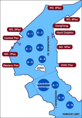
Outer
anchorage (Lower Masan)
Lower
Masan Bay is about 5.6km long and average 1,280m width with depth over
6 fathoms from Somo-Do north into the entrance to upper Masan Bay. The
5 fathoms curve runs close to shore throughout lower Masan Bay. This
area could provide, within a radius of 3.7km of the center of the port
facilities, 6 classes 11 free-swinging berths. The bottom being
predominantly mud provides good holding ground.
Inner
anchorage (Upper Masan) The harbour and middle part of bay have general
depth of 3¼ fathoms. However, there is a gradual shoaling to dry banks
at the head of the bay. There are depths of less than 4.6m
southwestward of a line from the position closed southward of pier No.
1 to the east end of the peninsula southwestward of Cho-Do. Vessel
drawing up to 7.9m can anchor in 10m mud, with the north side Cho-Do
island bearing 242°, about 7.32m from the island. Only one vessel
drawing over 7.32m can anchor in upper Masan harbour because of the
numerous shoal spots. Vessels with similar draft should consult with
their agents, at least 48 hours in advance of ETA in order to insure
that an anchorage berth is, or will be, available upon arrival. There
are nine designated free swinging berths, numbered A-1 through A-9 in
Lower Masan harbour.
|
| 10)
BUNKERING |
| |
There
is no bunker suppliers/facilities. Therefore, bunker (if requested)
should be supplied by lightering from Port of Pusan.
|
| 11)
SHORE CRANE |
| |
About
9 units of 25-170 tons of cranes are available through the stevedores |
| PIER |
LENGTH(M) |
DEPTH(M) |
BERTHING
CAPACITY(DWT) |
NO.OF
BERTH |
CARGO |
| NO.1 |
140+160 |
7.5 |
8,000
X 2 |
11 14 |
KAOLIN,S.SCRAP,ANTHRACIATE
POTTERY STONE
STEEL BAR AND S.BILLETS |
| NO.3 |
420 |
10.2 |
20,000
X 2 |
31 34 |
G.CARGO,FROZEN
FISH, PIG IRON
STEEL STRUCTURE, PIPE AND
PULP ETC. |
| NO.4 |
1,050 |
10.3 |
20,000
X 5 |
41 49 |
CONTAINER
AND HEAVY CARGO,
TAPIOCA, CAR |
| NO.5 |
420 |
10.5 |
20,000
X 2 |
51 52 |
LOGS
AND STEEL SCRAP ETC. |
| WESTERN |
821 |
7.5M
QUAY SIDE |
20,000
X 3 |
S1 S9 |
SCRAP,LOGS,PULP,F.FISH
AND OTHER STEEL PRODUCTS
ETC. |
|
|
